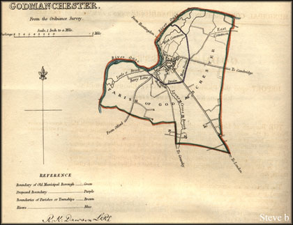
THE Borough of Godmanchester, or Gumecester, is co-extensive with the Parish of the same name in the County of Huntingdon.
It is situated on the Southern bank of the navigable River Ouse, which separates it from the adjoining Borough of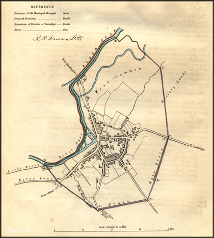 Huntingdon, and occupies a space of about four miles and a quarter of the-rìver's bank, from East to West, at an average breadth of about one and three quarters, comprising an area of 4,667A. n.. 2R 36p., according to a survey made in 1803 under an inclosure Act; about 50 acres of this land are in roads, drains, &c.
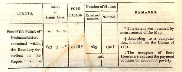
The Parish is an agricultural district, containing (with the exception of the Town) not more than three or four small cottages, inhabited by servants of the proprietors of the land. The total annual value of the real property value of the the parish, áccording to a valuation made thereof in 1825, for the pnrpóse of parochial assessment, is 7,8761. 16s. 3d. * The Population of the Parish (according to the Census of 1831) is 2,146.
The Town of Godmanchester is situated on the bank of the river. There are a few good houses, but most of the dwellings 'are mere cottages, and the general appearance of the Town does not bespeak any great prosperity. There has not been any increase of buildings for some years; nor does there appear any probability of such taking place. There are no manufactures, nor wholesale trades, carried on within the Borough; and the Town is neither paved nor lighted. The total Number of rated Houses in the Town, is 421 ; the Occupìers of 132 of these are excused payment of rates on account of poverty.
The total annual value of the houses is 2,004.; the value of the land, 5,872.
The Parish of GodmnachesteR' was incorporated by the Act of 2 & 3 Will. lV. c. 64, with the Borough of Huntingdon, for the purposes of electing Members to serve in Parliament. The great extent of the Parish, and the dispropońion, above stated, between the value of the land and the houses, together with the practicability of including all the houses within a Boundary more circumscribed than the present one, induce us to suggest the propriety of limiting that Boundary.
We therefore recommend the following Boundary; viz.
From the Point (I) at which the Northeastern Boundary of West Common meets the River Ouse, Southward, along the said Boundary to the Point (2) at which the same meets a Field-Brook which West Common from the Rectory Lands; thence in a straight Line to the Point (3) at which the Main Drain crosses the Cambridge Road; thence, Southward, along the Main Drain to the Head of the same (4) ; thence in a straight Line to the Point (5) at which the London Road meets a Drain, which divides a Field belonging to the Heirs of John Martin from three Closes, belonging spectively lo Henry Sweeting, Esq., George Maule and John Pacheller; thence, Westward, along the said Point (6) at which the same Lyons Crosà Brook (or, Thick Willow Brook); thence in a straight Line to the Point (7) at which Berry Lane meets the Offord Road ; thence in a straight Line go the Easternmost Point (8) which Leeds Brook joins the River Ouse; thence, Eastward, along the River Ouse to the Point first described.
We herewith transmit the Return of the Overseers of the Parish, of the Persons rated for the year 1835:-
1835 - Number of persons rated for Houses, Warehouses, Counting Houses or Shops, and who were not excused on the account of Poverty - 289
S. A. Rumball. Gust. Du Plat.